Sunday, January 22, 2017

The Barrier Islands and Reflections


Our dock at St Marys.  Most always we are the smallest boat!
We’d heard about the little town of St. Mary’s, Georgia. It is on the St. Mary’s river dividing Florida
 and Georgia, in the southeastern corner of the state. The dockmaster is 86 years old and works 7 days a week. He doesn’t answer radio calls or the phone, so we took a chance on getting dock space. The marina is home to the ferries taking visitors to Cumberland Island. Several ferries left and returned both days we were in the marina, loaded with people off to camp, hike or beach on this beautiful island. We had been on the island on our way down last all, and enjoyed an 8-mile hike that featured wild horses, armadillos and stately live oaks around the former Carnegie mansion. 

In St. Mary's, little shops and restaurants cater to the Cumberland Island tourists as well as the town residents, making this a busy little town.  We biked around the quaint town, and went in the large, old cemetery at one end of town. We saw markers from the early 1800s including a small section of Acadians, some  of whom settled in this area after being driven out of Canada by the British. We will definitely return to St. Mary’s someday. 

Molly bicycling by the former Jekyll Island Club.
Graveyard Beach. Not as isolated as the
Boneyard on Blackbeard so Molly tried
to make it as unique with her dance.
After 2 nights, we set off for Jekyll Island. This island was purchased in the late 1700s by a French family and sold in the late 1800s to a group of wealthy families who called themselves the Jekyll Island Club. The State of Georgia bought much of the Island in the 1950s.  There are some beautiful mansions and some concentrated residential development on the island, but the State passed a law that no more than 35% of the island can be developed, leaving lots of beautiful open land. We borrowed old fashioned single speed Schwinn bikes from the marina(we had sold our bikes in St. Mary’s) and rode on a bike path around the perimeter of the island, about 15 miles.
One of the prettiest parts of the ride was through a marsh filled with beautiful birds.

There was a heavy fog on the water the next morning, so we waited until it lifted. Shortly after setting out, we entered a thick fog bank and had almost no visibility for about 2 hours. We motored slowly, turned on our radar and hit the horn at regular intervals. The unnerving part for me was having to cross a big ship channel.  Being in the fog in a boat is a strange experience, but we have had many foggy sails in Maine, so we
Finally the fog began to lift.
knew what to do. In time, the fog lifted to a gorgeous and mostly wind free day.  We wanted to head back to Blackbeard Island that we had so loved on the way down.

Cabretta Inlet at low tide.
The weather and tides allowed us to enter Blackbeard Creek through the Cabretta Inlet from the Ocean.  The channel is unmarked, and it was somewhat scary for me (not for Bill, of course!) with waves crashing on both sides of us, but we made it through without incident.  Our anchoring spot was a mile or two up the creek, between Sapelo and Blackbeard Islands.  During the afternoon we took our dinghy down near the southern tip of Blackbeard and walked two beautiful miles on the beach and then circled back on the inland side along the Creek. 
 

I wasn’t thrilled as what turned out to be a bushwhack that featured cactus, tall marsh grass and some mud. Without saying this to Bill, I was thinking that we might be invading the privacy of some hibernating alligators.

Walking the sand roads on Sapelo Island.

Once back at the boat we got the phone number off the internet for JR Grovner, one of the descendents of slaves who lives on Sapelo Island.  Sapelo first became the home for a number of former slaves after the Civil War, and this history reminded us of much, much smaller Malaga Island in Maine.  Now, many of the descendants can no longer afford to live on Sapelo because of the increase in property taxes.  Most of the large Island is still wild, however.  Mr. Grovner was unable to give us a tour on the private island, but he did give us permission to visit.  In our 9 mile circular walk on the sand roads we passed two houses, the African Baptist Church, the ruins of the Chocolate Mansion, a former cotton plantation, and an ancient Native American shell midden, which has been carbon dated to be over 4,000 years old.


Former slave cabin at the Chocolate Mansion. The building was made of tabby, a common 17th century building material
made of shells and limestone.
Irrigation canal that served the
Chocolate Mansion plantation.


Main fireplace of the plantation house.


Indian midden known as the shell ring.


Last night for Molly at anchor


We got back to the boat late, and were challenged to make it north through the Creek back to the Intercoastal Waterway as the tide was going out.  We anchored 25 miles north in Redbird Creek, observing both a beautiful sunset and sunrise before going on to Hilton Head, where our boat will spend the winter.
Do not trust this nun to mark
the channel.
Nor can you trust this can.


On our full day of cruising we commented on how few boats we were seeing in comparison to our trip down.  First it is winter, and, secondly, the ICW, which is supposed to be 12 feet deep at low tide, went down to 4 feet in one section as suggested by both the red and green channel markers lying in the sand.
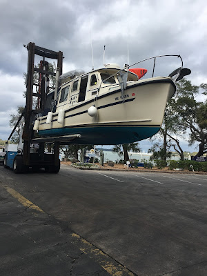


Our boat in now "on the hard" at the
Hilton Head Boathouse.

On the final day of our adventure, there is some time to reflect on this experience. Over dinner at the Hilton Head Boathouse we both came up with the same top four memories of our trip – going through the 8-10 foot breaking waves off West End, Grand Bahama, coming into the picture-perfect anchorage at the Exuma Land and Sea Park in the Bahamas, exploring Boneyard Beach on Blackbeard Island and the friends we have made.  We have had a lot of great laughs. Boaters are wonderful people, open to making new friends, willing to help each other out of jams, and always ready with a few snacks for cocktail hour in the cockpit. They also share a sense of adventure and love of storytelling that is delightful.

We learned that one can live reasonably comfortably in 125 square feet, privacy is overrated and you won’t starve if you have enough rice, oatmeal, potatoes, cabbage and peanut butter aboard.  This adventure will be hard to top, although we are working on other ideas, and we are so thankful to have had this opportunity. Thank you all for following our journey.

Monday, January 16, 2017

Back in Florida


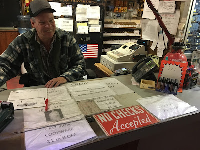
We have had limited exposure to Florida and have been pleasantly surprised by the number of energetic, pretty communities along the ICW in central and northern Florida including Cocoa, Fort Pierce, New Smyrna Beach and St. Augustine.   In Cocoa we shopped at the fascinating 130-year old, multi-building Travis Hardware.  Authorities would have closed the store as a fire hazard in Maine, but it was great as you can see in the pictures.  We told them that they should charge admission.
Cast iron cookware is 21 1/5% off!  We were told that helps the 80-year old
owner remember the discount,

Does anyone need a wagon wheel?
Is this walkway between
buildings safe?
Defrosting the refrigerator.
The boat is now 100 pounds lighter.
We enjoyed three days in Fort Pierce, shopped the great Farmers’ Market there, performed various maintenance projects and packaged and shipped four boxes home including the one thing that we found made in the Bahamas – rum cake in 6 different flavors! 

South of New Smyrna Beach, we rescued a disabled boat with three adults aboard and towed them 5 miles to the boat ramp where they had started.  We were already low on gas, and the boat owner had arranged for fuel for us at the boat ramp.  He insisted that we take some of his money and treat ourselves to a good meal in New Smyrna Beach, which we did.

Our friends getting ready to depart.
The boating community is generally very supportive and friendly.  Among our new friends are the Allen family, whom we saw briefly at the Boat Basin (months ago!) in New York City, passed in Delaware River and met in Delaware Gap.  We have texted back and forth multiple times about conditions and were pleased to see them again in St. Augustine, where we shared a great meal on our boat, thanks to Ann bringing the food. 


Our boat was the only pleasure boat in the free marina!

From St. Augustine we motored to Jacksonville and much enjoyed our stop there at the free municipal marina located in the shadow of the former Gator Bowl, now the home of the Jaguars, their NFL football team.  The city seems to be up and coming, and we walked around the city, including the Landing, the restaurant and cultural center.  The next day (Friday the 13th!) we continued up (which is south) the beautiful St. Johns River to Julington Creek for gas.  Another time we would like to continue exploring the St. Johns River, which flows another 150 miles south through the center of the State.

We enjoyed the aroma of the Maxwell
Coffee plant.
Home of the Jacksonville Jaguars.

We still don't have a good dolphin picture!
After a great lunch at the Fish Camp restaurant, we reversed course back through Jacksonville to the ICW and headed north.  Our original destination was Ferandina Beach, but the mooring field there and marina (like many others) was devastated by Hurricane Matthew, and won’t open again until March.  Instead we anchored in the Amelia River, where we watched dolphins swim by the boat, and Molly gave me my first haircut in over three months.


Tomorrow (1/14) we cross into Georgia, but leave Florida with a much improved picture of the state along with the thought that maybe we could live there for a few months a year!  Time will tell.


Saturday, January 7, 2017

Drama at Sea


Time to leave paradise.


Our trip from the Exumas back to the US required four open water passages ranging from 35 to 60 miles each.  One leg was over a typical shallow Bahama bank with 10-20 feet depths, while three of the passages were largely over ocean waters with depths between 3,000 and 6,000 feet.  There is something quite unsettling about knowing that one has a mile or so of water beneath the hull, and the unknowing of what may linger there.  In deference to a request from Molly, I never mentioned when our depth meter was beyond its 200 or so foot range. 


The level of anxiety at sea beyond water depth is much related to the strength and direction of the wind, and wave height and frequency.  These factors become accentuated by at least three factors: (a) the amount of fetch, or the distance of open water where waves can build in size and intensity; (b)  differences in the wind and wave directions, which can intensify turbulence; and (c) great differences in typography, particularly when open ocean meets shallow inlets.

Harbor Control gave us permission to pass
through Nassau harbor.
Leg I from the Exumas to Nassau was all over shallow waters and moderate winds and waves.  While not smooth, Molly was reasonably happy and enjoyed sipping coffee in her new YETI mug, a great Christmas gift from her husband.  In Nassau we fueled up and enjoyed viewing the cruise ships and all the boating activity. 

This cruise ship is beyond massive.

Leaving Nassau Harbor.


Leg II was from Nassau to the Berry Islands.  While very doable in our boat, the open ocean seas were more uncomfortable, and we were both glad to get in the lee of these Islands, where we spent the night. 

Leg III brought much anxiety, followed by peacefulness and then terror.  The first 50 miles were over open ocean.  Waves averaged 3 feet, not the 2 foot or less forecasted, and winds were blowing 20 knots, not the 15 knots or less expected.  I tried tacking, as one might do on a sailboat, but I had difficulty finding any comfort, regardless of direction.  We alternated between pounding over the waves going into the wind to surfing down the waves with increasing speed and needing to guard against the boat broaching,  where it can suddenly turn sideways to the wave and seem like it might tip over.  We got pushed by one particularly large wave, and Molly cried, “God, please don’t kill me today!”, or something to that effect.  Finally, we settled on heading the boat so that the waves were just aft of our beam.  This greatly reduced the pounding, yet the waves were enough behind us so that the boat would not surf. 
Abandoned work boats and equipment at the beginning of the
Grand Lacayan Waterway.
 We changed our landfall according to our more comfortable direction, and all seemed reasonably good until Molly observed a squall, a very dark and fast moving system, coming at us from our port beam.  We could see the downpour and increase in white caps caused by the stronger winds.  I sped up as much as I could, and, fortunately, we were able to stay in front of the squall until we got in the safety of the Grand Lacayan Waterway. Some white knuckles, for sure.

This hotel on the Waterway was never
finished.


The Waterway is a 7-mile canal that follows a north-south line through Grand Bahama Island.  Off the canal are various canal tributaries, constructed to serve hotels, condominiums and luxurious single family houses with boat docks.  The hope was that this would become a Venice West, but it ended up being both the biggest public works project and boondoggle in Bahamian history. 
After passing through the tranquil, yet ghostly Waterway, we entered the Bahama Bank north of Grand Bahama.  Now in the lee of wind and waves, we easily sped along toward the marina in West End, closest point to Palm Beach, FL, our US destination.  Within a mile or so from the marina, we came to a dead stop as we observed a line of crashing breakers marking the shoal inlet that had to be crossed to reach West End.  I then motored the boat forward slowly as the frequency and height of the swells increased.  As the waves reached four feet or so, and not being prepared for worse, I quickly turned the boat around, returning to smoother waters to contemplate our options.  We had enough fuel for, perhaps  40 miles, and there was another inlet to cross the shoal 16 miles to our north.  We could also return to the canal, but there were no services for 50 miles or so.  Another factor was that it would be dark in less than two hours.

At that moment two 50+ foot sport fishing boats motored past us heading toward the inlet that we had just turned back from.  We connected over the radio, and I decided to turn around again and attempt to follow them through the shoal inlet.  “Molly, get our life jackets! Lock the doors!” The two boats in front of us were now in the middle of the 8-10 foot waves, and we could see the waves of water going over their fly bridges.  With no other viable options, we followed them in and soon hit the same waves.  The boat seemed to reach vertical  going up the waves, was nearly airborne at the top, and then crashed down the back side with the bow being briefly buried before rising again to go up the next wave.  It seemed like an eternity, but it what was probably just a few minutes, and we were over the shoal, now dealing with very unsettled seas with 4 foot waves.
I asked Molly to turn on her windshield wiper as I could no longer see out the port side window.  In her haste, (and maybe panic), she turned off the electronics.  We were now separated from the two other boats, and I couldn’t discern the marina breakwater entrance.  While the electronics were slowly restarting, Molly tried hailing the marina on Channel 16 multiple times, but there was no response.  Finally, another boater on shore came on 16 and directed us to the marina entrance.  As we entered, the other two boats, Tango and A Reel Dive followed us in.  Once docked we all breathed a sigh of relief and compared notes on the pier.  The Tango captain said that they saw Salty Paws completely out of the water on two occasions.  That night we both had two stiff drinks with a great dinner of Bahamian grouper.  I told Molly that this was the first time I had thought that we might not make it. 

We slept well but woke up the next morning, not sure if the weather would permit a crossing from West End to Florida.  The captain of A Reel Dive, Angel Cruz, was very friendly and confirmed with our weather service that today, Thursday, 1/5, was the day.  We then learned that his companion boat, Tango, had just locked into reverse and rammed the dock on the opposite finger pier.  There was very little damage to the boat, but six wooden pilings were demolished as well as Tango’s dinghy.    
Angel asked if we would work with him to tow Tango out of the inner harbor where they would be able to lock the boat in forward for the crossing and then seek further assistance in the States.We did just that before our own departure. After all, our boat make was designed for the Canadian Coast Guard! 
Our first view of the USA in almost one month.


Leg IV was our 60-mile crossing from West End to the Palm Beach inlet.  The trip was uneventful, and we arrived in Florida three hours later.


After checking in with US Customs, we motored up to Manatee Pocket in Stuart for a relaxing evening at anchor.


Friday, January 6, 2017

Exuma Paradise


 We left Nassau on 12/27 for the Exumas with a full gas tank, a new battery (of four), fresh food and a favorable forecast. We were initially headed for Warderick Wells, center of the National Park, about  56 miles away. The trip would be over the Yellow Bank, with 15-25 feet of aquamarine water and light chop. The chop was not light at all with water crashing over our bow and top. We changed courses to head to Allan’s Cay to take 20 miles off. We found a beautiful anchorage in shallow water, right off a small beach.

The largest iguana that we saw - about 3 feet long.
Allan’s Cay is one of the northernmost frequented anchorages in the Exumas and known for its colony of iguanas. The story goes that the Spanish colonists eradicated these creatures off most of the islands, but did not come to Allan’s. We took our dinghy to the beach and began looking for life. We first spotted a large fellow, maybe 3 feet long, partially hidden behind a rock. Then more and more smaller guys started approaching from behind the jagged rocks.  
Iguanas came from everywhere as we departed.


These creatures have a reputation for biting, so we didn’t want to get too close. After observing them for a while, we headed back to the dinghy. We were then rushed by quite a few, presumably looking for hand outs.


The next morning we set off for Warderick Wells, the headquarters of the Exuma Land and Sea Park, one of the highlights of our trip.  We had read that the mooring field in the park can be booked early and we needed to call by 9 o’clock to get a spot. We sped up our trip to make it in calling range by 9 and felt lucky to get a mooring reserved. Cherry, the harbor manager, guided us in, “Follow the darker water to the last mooring.”


On a mooring at the Exuma Land and Sea Park

View of our anchorage from Boo Boo Hill.


We slowly motored into absolute paradise. As rumored, the waters here are crystal clear and have every color of blue green from the palest aquamarine to deep sapphire.


After checking in with Cherry, we snorkeled in the Garden, seeing beautiful live coral and colorful fish. There are many reefs in the park that are identified on charts for visitors to explore.  We much enjoy having a camera that can be used underwater but the pictures never capture the full vibrancy of the color.


Notice that there is a fish swimming under the right fin of the string ray. 


Molly is etching our boat name on drift wood.


Placing our boat name on the pile.
Boo Boo Hill.
Later in the afternoon we took a hike through parts of the island. We walked on sharp, jagged rocks along a mangrove creek where we saw a young stingray and young turtle swimming in 5-6in of water. We hiked up to Boo Boo Hill where we followed the example of thousands of other boaters by making an offering to the sea gods with our boat name on a piece of drift wood.


One of many beaches we walked
with no footprints.
We spent five days and four nights in the Park, which encompasses a number of cays over 150 square miles.  The Park was created in 1958 with the support of volunteers.  This is a very special place, and one that we hope to visit again, perhaps, as park volunteers as the trails could use some work.   We already started volunteering by picking up some of the plastic that had washed up on Boo Boo Beach.  We were told that last year, cargo debris from the wrecked El Faro landed on the Exuma Islands, including millions of bags of M&Ms, bottles of Axe Body Wash, flea collars, cans of motor oil and medical supplies, including wrapped syringes. During our time in the park we snorkeled, kayaked through the mangrove, explored all the hiking trails on the Cay and celebrated New Year’s Eve on the beach with fellow boaters from the USA and Canada.

Banshee Creek with its mangroves.
The bridge on this trail seems only partially helpful!

View of Hutia Hill where we saw our first Hutia,
similar in size to a woodchuck.


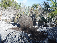
Termite mound.

We want to moor here next time! 


English remains on the island.


Boaters tend to be very friendly, often exchanging information and sharing appetizers on each other’s boats.   There were a handful of cruisers that we saw three or four times over the course of a month or two even though very few travel on a planned schedule.  Two couples, in particular, we hope to visit in Canada.  Interestingly, the majority of boaters we did meet were from Canada.


One of the private island beaches we viewed from our boat.


After the Park we continued our journey south, motoring past some of the private cays owned by Johnny Depp, Tyler Perry and others.  We ended up anchoring off Big Major Spot in front of the famous “swimming,” wild pigs on the beach.  Some of the pigs are as large as a cow, and boaters take their dinghies ashore to see and feed the animals.  One needs to be careful since they can bite, raise their feet up on dinghies while looking for handouts and chase people down the beach.  One poor teenage girl ended up in tears as a number of pigs chased her as she held her bag of chips, one getting a small nip of her behind.  We didn’t understand why she just didn’t just drop the bag.  Bill wore a diving  glove and coaxed a couple of pigs in the water before giving them carrots. Hungry little buggers!


After running from pigs for 15 minutes,
one jumped on her leg, and she dropped
the package of chips.

Bill got the pig to go out another few feet before taking the carrot.

The most common topic for boaters is the weather.  This is particularly important in the Bahamas as the 40-70 mile stretches of open ocean between island groups become impassable with winds of certain speeds and directions and/or waves of certain heights and above.  Nearly everyone subscribes to some type of weather service.  On Sunday night (1/1) we compared weather notes over cocktails with our friends Ken and Merydie.  It looked like Wednesday or Thursday would be our “weather window”, the only days that we would be able to get back to Florida over the next two weeks due to high winds expected.  The next morning we putt putted to Staniel Cay for gas and water and then began the journey home.