Saturday, March 2, 2024

My Guardian Angel, Citrus Devastation and Lake Okeechobee


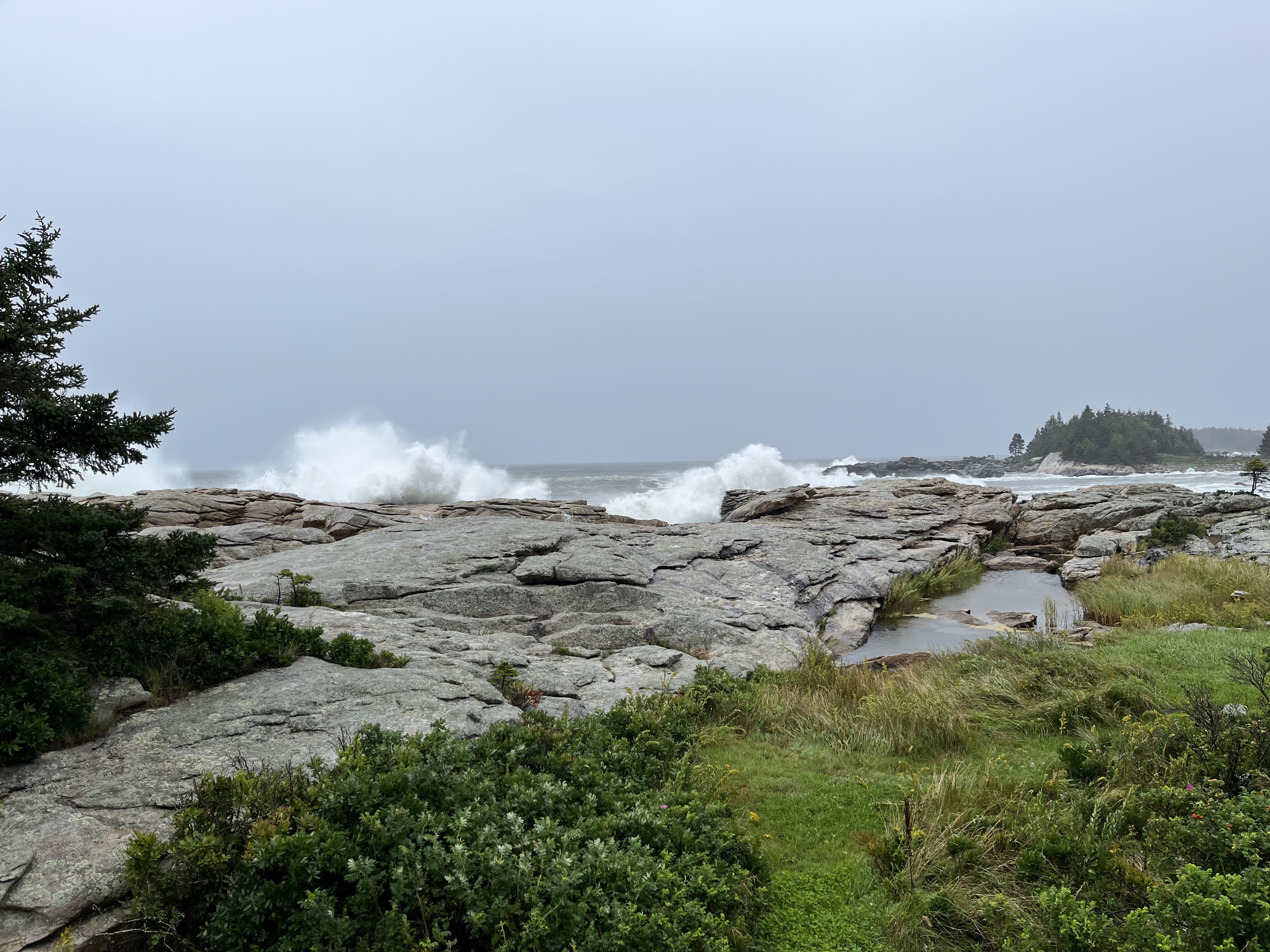
Our house after the two January storms.

Before the storms reached their peaks I sent Molly and Tory up the hill to cousin Cliff's and Norah's house.  I stayed in our house except for 90 minutes when my escape route was getting too narrow.

As waves crashed at our main steps, I could hear things being banged around in the basement.

To what do we owe misfortune – bad luck, poor preparation on our part, the wrath of God or maybe God helping prepare us for life?  Likewise, to what do we owe our good fortune – luck, good preparation on our part, the grace of God?  It helps, I believe, to look on the bright side of things, and I have always had the feeling of a guardian angel watching out for me.  The concept of a guardian angel has many roots although not specifical referred to in the Bible except, perhaps, Psalm 91:11 that reads ‘For he will command his angels concerning you to guard you in all your ways.”

This was taken from our front porch before the dune was washed away.
One can see the height of the wave crashing over the rocks next to our house.

Our misfortune began in January with two of the most devastating coastal storms ever recorded.  They occurred only 3 days apart and were both worse the Storm of 1978, which, at the time, was considered a once in a 500-year event.  Tides for both January storms were more than 6-feet above normal, and 20-foot waves crashed over our 300-foot wide rock promontory to our house.  The waves took out our steel basement door and destroyed everything in the basement including our heating and water systems.  

Our propane tanks used to be here.
Our wonderful sandbag party in 15 degree weather.


We lost our propane tanks, our shed, 25-feet of dune, one deck support and three sets of outside stairs. Yet, other than some shingles ripped off the house from waves, our first floor was untouched.  Then, just one week after the second storm, 65 friends and neighbors showed up to clean up our yard and beach, fill 1,500 sandbags and place the sandbags around our foundation.  Insurance monies have funded moving the furnace to the first floor and our water system repairs.  We may ultimately lose the war to rising tides, but we will be much better prepared for the next big storm.  Thank you, guardian angel!

Good friends Jon and Otto stand
in front of the finished work.
 

On our way south!

This side of the trailer axle moved
4 inches back after hitting the curb
Molly, Tory and I are now in Florida on Salty Paws.  The trailering south was not without mishap.  We had a tire blowout, and a trailer axle hit a curb in a gas station and moved back, crushing the left-side fender.  Yet, these mishaps emphasized the importance of checking and tightening all the brackets on the trailer.  What if the trailer axle had moved back when we were going 60 mph, not 3 mph?  Thank you, guardian angel!

Getting ready to leave with a wonderful
goodbye from granddaughter Charlotte
and her good friend Ella.

Our RVs looked a little different!

We met our Looper friends Barb and
Jay after 4 1/2 years.  They are now
RVers, and we met at an RV park.
We stayed with friends, relatives and Hampton Inns on the way south, and after spending a week with daughter Liz and family, used the boat as an RV in Florida.  As we headed further south through Central Florida, we could not help but notice some of the devastation to the citrus groves.  As much as 90% of the Florida citrus crop has been impacted by Citrus Greening, likely the deadliest citrus disease in the world.  


Orange grove.
These young, covered orange trees almost
look like a grave yard.

The disease first appeared in Florida around 1995, carried by an Asian beetle.  Once a tree is infected, there is no cure.  Much work is being done on developing a resistance orange tree, and younger trees are being blanketed with netting to better protect them from the disease.  Citrus Greening has resulted in the layoffs of thousands of farm workers, and essentially eliminated the small orange farm producers.

We finally launched Salty Paws in Indiantown, just each of Lake Okeechobee.  The marina here will store our truck and trailer, until our cruising ends, likely by mid-April as we need to get back to Maine to start planting beach grass.  After a night at the marina, we began our cruise west on the St. Lucie Canal and entered the Mayaca Lock for entrance to the Lake Okeechobee.

Looking out from the Clewiston lock to the Lake.

This large, shallow lake is roughly 50-miles across, and its depth can range from 12-18 feet.  The depth is impacted by rainfalls and runoff and is regulated by the Army Corp of Engineers.  Flooding is a big concern, and adjacent towns and the extensive agricultural lands and cattle ranches are protected by levees, locks and dams.  What was not understood at the time during this 1930s construction was that this would impact the natural flow of water to the Everglades.  Today the Everglades is half of what it was in the 19th century.  While land has been used for development, the State has also lost some of its biodiversity, natural flood control and water quality.

In addition, the levees, locks and dams do not protect Florida waters from being overwhelmed with chemical and nutrient runoff to the Lake and down the canals and rivers to the west and east coasts.  Friends in Cape Coral and North Fort Myers tell us of pristine coastal water turning brown and leading to algae blooms after the Lake is lowered by the Army Corps of Engineers during the winter.  The lower lake level is needed to ensure that summer rains will not overwhelm the levees and flood local communities.   

Tory put her ball in the water in one
of the 4  locks we went through.
Molly was able to retrieve it.

Salty Paws in Clewiston.
Both Molly and I are fighting colds, maybe because we are not used to this warm weather!  We have now cruised 150 miles to the West Coast after visited Clewiston (known for bass fishing), LaBelle (known for honey), Cape Coral (dinner with friends Sue and Alan and Captiva Island (celebrated my birthday with cousin Cliff and Norah).  Our destination is the Burnt Store Marina, where we will participate in a Rosborough Boat Rendezvous March 3rd-6th.   

We met Cliff and Norah in Captiva.  Their
rental car was very distinctive!


Saturday, September 16, 2023

Hurricane Lee and Home

Molly took this picture looking toward our cottage the night before Lee, now a tropical storm, arrived.

Ground Zero in early November 2001.

Dick and I awoke in Annapolis Royal, Nova Scotia, on Monday, September 11th.  We talked about that day in 2001, and I reflected on our family visit to New York City less than two months after the tragic event.  Caroline and I visited Ground Zero, one of the most emotional visits of my life.  Signs of patriotism were everywhere, and the flowers and messages left for loved ones were heart wrenching.

We then turned our attention to the updated weather forecast for Hurricane Lee.  It looked like Maine or Nova Scotia might well get a direct hit, and I knew that Molly was anxious for my return.  The decision was made to head the 250 miles home and forego our plans to see the reversing falls in St. John, New Brunswick, to visit Campobello and to gunkhole back down the Maine coast. “Come Home” was now our mantra, just like the Newfoundland license plate pictured below.


Newfoundland & Labrador’s license plate message is “Come Home.”  The province is forecasted to lose 10-20% of its population over the next 10 years as younger residents move away to find more and better opportunities.

The Bay of Fundy.

The fog was thick, the winds nonexistent and the Bay of Fundy like glass.  We wanted to conserve fuel as we weren’t sure where our next fuel stop would be.  Salty Paws cruised along at 9 mph, and for 10 hours we saw no land.  We did see one huge tanker, several guillemots, gulls, gannets and seaweed.  We also had a brief encounter with one small bird that came close to flying right into our cabin.  Dick enjoyed seeing me frantically flapping my arms to keep the bird out.  Our visitor rested on our foredeck for a few seconds before flying off.  I have never had an avian hitch-hiker, but Dick has encountered them many times while sailing.

As we approached US waters, I used the US Customs app to apply for re-entry to our country.  About 10 minutes after hitting the send button, I received the message “Unfortunately, your application has not been approved and you may not enter the U.S. at this time.  You may contact the nearest Port of Entry for information or clarification.”  Yikes!

After an Internet search I was finally able to get a phone number and contacted the Lubec Customs office.  I learned that our boat had probably still been in Canadian waters and that led to the rejection.  After re-applying, we were soon contacted by a Customs official.  We video-conferenced so he could see our faces and get a tour of the boat.  He was satisfied and welcomed us back to the U.S.

Dusk was now approaching, and with our radar and GPS we found the entrance to Cutler Harbor.  We eased Salty Paws into the inner harbor and passed a lobster boat with four people sorting the day’s catch.  They were happy to direct us to an open mooring for the night.

Dick sleeps in the cabin while I sleep in lower v-berth so he hears and sees a lot more than I do.  From 3:30 am on his slumber was interrupted by departing lobster boats while I continued my beauty rest until almost 5:30 am.  I decided that the least I can do is make a nice breakfast of two hole-in-the-walls each (eggs fried in a hole in a piece of bread). 

The yellow dots are lobster boats.

We determined that we have enough gas to go the 65 miles to Northeast Harbor on Mt. Desert Island where we can refuel and possibly make Port Clyde for the night.  Again, it was foggy, but our radar easily showed the location of the working lobster boats.  We follow the course plotted to Mt. Desert, while dodging lobster boats along the way. At one time the fog temporarily lifted, and we counted 10 lobster boats within two miles of Salty Paws.

After refueling, we decided to zip past Port Clyde and cruise the 95 miles all the way to Robinhood, our homeport in Georgetown.  While crossing Penobscot Bay, we passed an old wooden schooner that Dick identified as once belonging to his father.

After almost 10 hours of travel, Salty Paws pulled into Robinhood with 2,800 miles behind her.  Soon Molly and Tory were on the dock, and Tory gave me the most excited welcome home I have ever had including peeing all over the dock.

Addendum #1

 Salty Paws was pulled out of the water two days before Lee, and Molly an I were able to get the house ready for the blow.  Lee arrived on Saturday, September 16th, now as a tropical storm.  We experienced high surf and northwest wind gusts approaching 60 mph, but had no damage or flooding.  The power did go out, but our generator, relocated from the boat, keep our lights on and refrigerator cold.  All is good.

Addendum #2

I have added an addendum to this blog to give thanks to all who made my cruise completing the Down East Circle possible and enjoyable. Most are Rosborough owners.
Molly Webster, boatmate from Maine to Quebec City and super supportive partner;
Richard Klain (Dick), awesome boatmate from Quebec City to Newfoundland and back to Maine;
Rosborough owners Bear and Barrett Holliday Thompson, who gave me a number of paper charts covering much of our cruising area;
Jonathan Surgenor and Elizabeth Surgenor who joined us on their own boat from Lake Champlain to the Saint Lawrence River;
Rosborough owners Gary and Beverly Watson, who welcomed us to Lake Champlain and let us tie up to their wonderful dock and sleep in the airconditioned comfort of their guest house;
Rosborough owners Peter and Claudia Hornby, who gave us a wonderful tour of the lighthouse on Valcour Island and joined us for a great dinner in Plattsburgh;
Rosborough owner Jacques Thibault who only speaks French and reached out to us to join him, his wife Mimi and friend Michel Manningham at his home in Carlton-sur-Mer, Quebec, for dinner and breakfast and a wonderful 3-day cruise along the New Brunswick shore;
Rosborough owners Otto Cuyler and Rob Russell, who joined our adventure on their respective boats from Cape Breton to Newfoundland;
Rosborough owners Mike and Melissa Read, who welcomed us at the St. Peter's lock, took some great pictures, and shared some wonderful cruising ideas for the Bras d'Or Lake and Nova Scotia;
Rosborough owner Mark Uggeri who helped me improve my boat wiring and introduced me to Nagel Calder's great book, Boatowner's Mechanical and Electrical Manual. Mark also showed me how to make straps to hold up our cockpit canvas;
Rosborough owner Mike Anderson, who gave me a 15-foot electrical shorepower cable that made our cockpit so much less cluttered; and
Rosborough owner Bob Louthen , who gave me the idea to relocate my davit lift and make more room in our cockpit.
I am sure that I have missed someone!


This is Robinhood, our home marina, two days before Lee arrived.  The marina instituted hurricane procedures which meant that all boats either had to be hauled out or put on moorings. 


Lee arrived with 10-15 foot surf from the southeast, but the northwest winds kept the waves from washing over all the rocks into our yard.


The surf pounded the other side of our cove, but we were spared most of the force.


Sunday, September 10, 2023

The Great Halifax Explosion, the Bluenose, Fog and other Nova Scotia Highlights

Halifax

Panorama view of one of the cruise ships in Halifax Harbor.

Salty Paws in busy Halifax Harbor.

The Halifax waterfront has a mile boardwalk along the docks and is lined with restaurants and shops.

We steered Salty Paws out of main channel to let the car carrier Sunshine Ace exit Halifax Harbor.  The yellow boat will pick up the harbor pilot from the ship once it is outside the harbor.  The transfer is done while both boats are moving.

The year was 1917.  The day was December 6th.  World War I was raging, and the city of Halifax was a very active seaport being the closest major port to Europe.  Among the ships in harbor were the Imo, a Belgian relief supply ship, and the Mont-Blanc, a French munitions ship carrying almost 3,000 tons of explosive material.  Due to a series of ill-advised maneuvers, the Imo rammed the bow of the Mont-Blanc.  The collision itself was minor except that the impact started a fire on the French vessel.  As the fire intensified, many city residents hurried down to the docks to see what was happening.  
Picture taken at the Maritime Museum

 Twenty minutes after the initial collision the Mont-Blanc exploded with a violent chemical reaction, releasing energy at 5,000 feet per second.  Almost 2,000 people died immediately and another 9,000 were injured.  1,630 homes were completely destroyed, 12,000 houses were damaged and over 6,000 survivors were homeless.  Many of the windows throughout the city were shattered leaving many blinded and many in need of surgery to remove glass embedded  in their eyes.  The blast also created a local tsunami that wiped out a nearby community of the Mi’kmaq First Nation, that had existed for generations.

 The explosion was the largest man-made blast prior to the atomic bomb, and the recovery effort was made even more difficult when a snowstorm the next day dropped 16 inches of snow on Halifax.  If there was any good news about the explosion, it was the world-wide response to assist Halifax in its recovery.  Boston and Massachusetts were particularly helpful, and among their most prized contributions were window glass and 24 window glazers.  Every year Halifax and Nova Scotia cut and ship to Boston a magnificent, large Christmas tree in gratitude.

Halifax today is one of the fastest growing cities in  North America and has a population approaching 400,000.  The British founded Halifax in 1749 and made the city its base for naval operations in North America.  There were at least three reasons for this decision - the port is large, ice-free year round and close enough to counter the French fleet in Louisburg, located roughly 200 miles to the east.

We walked to the Citadel, a fort that has
  been rebuilt 4 times and protected the
city for 200+ years.

At the Maritime Museum we learned that in 1758 the British surprised the French in Louisburg leading in short order to the French surrender there.  By 1763 the French had acceded all of Canada to the British.  Even after that, however, the British continued to have a large garrison in Halifax to guard against the upstart colonists and then the new United States.  In fact, for well over 100 years the Americans and the British viewed the other as the enemy.

The city continues to be a large shipping port, and the harbor is lined with a cruise ship berth, a large container facility and more.  The old wharves have been fully rehabbed and floating docks added for recreational boats.  Every 30 feet of dock has a reservation sign showing the boat’s name, length and dates reserved.  Unfortunately, the wharf reservation system is questionable as they do not take same day registrations, payment is only upon departure, and the majority of the reserved slips were empty.  

We were able to find one slip with an expired reservation date.  I tried to pay the dock fee over the telephone, but was told that they couldn’t take payment but would call back later.  (They never did.). Soon, we experienced the downside to this perfect location - boat wakes in the harbor.  Between the wakes and the partying (it was their Labor Day weekend), we didn’t get much sleep that night.

LaHave and Lunenburg

Salty Paws at Anne Huntington’s Bell Island dock.

The LaHave Bakery and dock.
Anne Huntington and Dick.

The LaHave Islands are beautiful, and we were blessed to be able to dock for the night and have a home-made dinner with Dick’s friend Anne Huntington at her house on Bell Island.  This was followed by two nights at LaHave Bakery, only a 5 minute walk from Molly and my friends, Merydie and Ken Houldsworth.  We first met them in the Bahamas in 2016.  

The LaHave Bakery along with a bookstore, consignment store and restaurant are all located in the restored LaHave Outfitters building that once served the now almost gone local fishing industry.  They have a dock where cruisers can dock free during the day or spend the night for $1 per foot.


Merydie and Ken.
The Bluenose II

 Merydie and Ken hosted us for cocktails and dinner, and Ken drove us to Lunenburg with its UNESCO designated world heritage site on its waterfront.  We toured the Fisheries Museum and walked aboard the famous Bluenose II.

The story of the boat is quite a tale, and started in 1920 when the Halifax Express newspaper offered a $4,000 prize for the fastest fishing vessel in a best two out of three races called the International Fisherman’s Cup Race.  To be eligible a vessel had to have fished in the Grand Banks for at least one season.

This topographical map in the Fisheries Museum shows the various fishing banks off the New England and Atlantic Canada.  The Grand Banks is off Newfoundland on the far right.

Elimination races were used off Halifax to determine the Canadian vessel and off New Gloucester, MA to pick the American representative.  To the surprise and consternation of the Canadians, the New Gloucester boat won the inaugural cup.  The Canadians then engaged in a crash course to design, build and fish in a new boat o qualify for the 1921 race.  The boat was constructed in Lunenburg and finished in less than 6 months.  It was named the Bluenose, the nickname for people from Nova Scotia.  After easily winning the elimination races to represent Canada, Bluenose won both races against the US representative and returned the Fisherman’s Cup trophy to Canada.  The boat also won the subsequent Fisherman’s Cup races in 1922, 1923, 1931 and the last one in 1938.  The age of sail was now completely over for commercial vessels as sails were replaced by steam engines.

Dick aboard the Bluenose II.


The Bluenose was a tremendous source of pride for Canadians and appeared in postage stamps and on the back of their dime.  It was sold in 1942, however, and met its demise in 1946 after hitting a reef off Haiti.   In 1963 the Orlando Brewery financed the construction of the Bluenose II to be used as a promotional yacht.  It was given to the provincial government in 1971 and continues to sail out of Lunenburg as an Canadian ambassador.


Nova Scotia Fog

Cape Sable Light.  The fog lifted temporarily to give us a great view. 

Our view from the boat while cruising from the Nova Scotia southwestern coast to the Bay of Fundy.

You can not read the ship
names, but each line is a wreck.


Almost 40 years ago my father, a friend and I sailed from Portland to Nova Scotia.  We arrived in fog, the Province’s 48th straight day of fog.  The cold waters of the Atlantic and moist southerly are a perfect recipe for fog.  Until this week we have had very little fog on this trip, but it arrived in earnest on our day to round Cape Sable, sometimes referred to as “the Graveyard of the Atlantic.”  Hundreds of vessels have run aground on its shoals, so a clear view is most desirable.  

We went by the Cat in Yarmouth before
it left on its daily run to Bar Harbor, ME.

Unlike the ships of the past, however, we have modern technology on Salt Paws including two depth sounders and two independent chartplotters using Global Positioning System (GPS) that show our speed, direction and exact location on the water.  Another great advancement is our Automated Identification System (AIS) that displays the position of nearby boats right on our chartplotter, and other boats can see us.  AIS is generally required on commercial vessels, and most cruisers also have the system.  We also blow our fog horn frequently.

We left our anchorage at Cape Negro Island across from Squaw Island (they still have these names?), and Dick and I swapped 1 1/2 hour shifts at the helm.  We would go crazy if we had to pilot boats in these conditions every day.  As Salty Paws approached Cape Sable, the fog lifted temporarily and sunlight radiated off the beautiful lighthouse.  After rounding the dangerous shoal, we soon found ourselves in fog again.  Twice we passed other boats only 0.2 miles away, but we never saw either of them.

Annapolis Royal

Salty Paws on one of fishing boat mooring at Annapolis Royal,

When we walked into the town on Sunday
morning, there was no one around. We
felt like we were on a movie set.
More than one Canadian told us that you have to go to Annapolis Royal, located 10 miles up the Annapolis River from Digby on the Bay of Fundy.  We took the bait and cruised up the Bay of Fundy to the quaint little town with quite a history including being the first permanent European settlement north of St. Augustine, FL.  The French established a presence here in 1605, although they would not have survived without the assistance of the local Mi’kmaq inhabitants.  Over the next 100 years the settlement and the fort here would change hands 6 times in battles between the France and Britain before the British prevailed in 1710. 


Dick and I toured Fort Anne here which was Canada’s first national historical site.   As in other historical sites we visited, we learned more about the expulsion of the Acadians and also the treaties made with the Mi’kmaq that were not honored by the British.

We were pleasantly surprised to find a bar that would let us watch the New England Patriots season opener, and below the TV was a Patriots helmet signed by Tom Brady!


Peggy’s Cove
Salty Paws is that little boat out there.

This is one of the top tourist attractions in Nova Scotia because of its picturesque lighthouse and quaint small harbor.  There are two live webcams there, and a Salty Paws was captured by both.  I observed 5 large busses in the parking lot.

Salty paws is in the center of the picture.