Saturday, September 16, 2023

Hurricane Lee and Home

Molly took this picture looking toward our cottage the night before Lee, now a tropical storm, arrived.

Ground Zero in early November 2001.

Dick and I awoke in Annapolis Royal, Nova Scotia, on Monday, September 11th.  We talked about that day in 2001, and I reflected on our family visit to New York City less than two months after the tragic event.  Caroline and I visited Ground Zero, one of the most emotional visits of my life.  Signs of patriotism were everywhere, and the flowers and messages left for loved ones were heart wrenching.

We then turned our attention to the updated weather forecast for Hurricane Lee.  It looked like Maine or Nova Scotia might well get a direct hit, and I knew that Molly was anxious for my return.  The decision was made to head the 250 miles home and forego our plans to see the reversing falls in St. John, New Brunswick, to visit Campobello and to gunkhole back down the Maine coast. “Come Home” was now our mantra, just like the Newfoundland license plate pictured below.


Newfoundland & Labrador’s license plate message is “Come Home.”  The province is forecasted to lose 10-20% of its population over the next 10 years as younger residents move away to find more and better opportunities.

The Bay of Fundy.

The fog was thick, the winds nonexistent and the Bay of Fundy like glass.  We wanted to conserve fuel as we weren’t sure where our next fuel stop would be.  Salty Paws cruised along at 9 mph, and for 10 hours we saw no land.  We did see one huge tanker, several guillemots, gulls, gannets and seaweed.  We also had a brief encounter with one small bird that came close to flying right into our cabin.  Dick enjoyed seeing me frantically flapping my arms to keep the bird out.  Our visitor rested on our foredeck for a few seconds before flying off.  I have never had an avian hitch-hiker, but Dick has encountered them many times while sailing.

As we approached US waters, I used the US Customs app to apply for re-entry to our country.  About 10 minutes after hitting the send button, I received the message “Unfortunately, your application has not been approved and you may not enter the U.S. at this time.  You may contact the nearest Port of Entry for information or clarification.”  Yikes!

After an Internet search I was finally able to get a phone number and contacted the Lubec Customs office.  I learned that our boat had probably still been in Canadian waters and that led to the rejection.  After re-applying, we were soon contacted by a Customs official.  We video-conferenced so he could see our faces and get a tour of the boat.  He was satisfied and welcomed us back to the U.S.

Dusk was now approaching, and with our radar and GPS we found the entrance to Cutler Harbor.  We eased Salty Paws into the inner harbor and passed a lobster boat with four people sorting the day’s catch.  They were happy to direct us to an open mooring for the night.

Dick sleeps in the cabin while I sleep in lower v-berth so he hears and sees a lot more than I do.  From 3:30 am on his slumber was interrupted by departing lobster boats while I continued my beauty rest until almost 5:30 am.  I decided that the least I can do is make a nice breakfast of two hole-in-the-walls each (eggs fried in a hole in a piece of bread). 

The yellow dots are lobster boats.

We determined that we have enough gas to go the 65 miles to Northeast Harbor on Mt. Desert Island where we can refuel and possibly make Port Clyde for the night.  Again, it was foggy, but our radar easily showed the location of the working lobster boats.  We follow the course plotted to Mt. Desert, while dodging lobster boats along the way. At one time the fog temporarily lifted, and we counted 10 lobster boats within two miles of Salty Paws.

After refueling, we decided to zip past Port Clyde and cruise the 95 miles all the way to Robinhood, our homeport in Georgetown.  While crossing Penobscot Bay, we passed an old wooden schooner that Dick identified as once belonging to his father.

After almost 10 hours of travel, Salty Paws pulled into Robinhood with 2,800 miles behind her.  Soon Molly and Tory were on the dock, and Tory gave me the most excited welcome home I have ever had including peeing all over the dock.

Addendum #1

 Salty Paws was pulled out of the water two days before Lee, and Molly an I were able to get the house ready for the blow.  Lee arrived on Saturday, September 16th, now as a tropical storm.  We experienced high surf and northwest wind gusts approaching 60 mph, but had no damage or flooding.  The power did go out, but our generator, relocated from the boat, keep our lights on and refrigerator cold.  All is good.

Addendum #2

I have added an addendum to this blog to give thanks to all who made my cruise completing the Down East Circle possible and enjoyable. Most are Rosborough owners.
Molly Webster, boatmate from Maine to Quebec City and super supportive partner;
Richard Klain (Dick), awesome boatmate from Quebec City to Newfoundland and back to Maine;
Rosborough owners Bear and Barrett Holliday Thompson, who gave me a number of paper charts covering much of our cruising area;
Jonathan Surgenor and Elizabeth Surgenor who joined us on their own boat from Lake Champlain to the Saint Lawrence River;
Rosborough owners Gary and Beverly Watson, who welcomed us to Lake Champlain and let us tie up to their wonderful dock and sleep in the airconditioned comfort of their guest house;
Rosborough owners Peter and Claudia Hornby, who gave us a wonderful tour of the lighthouse on Valcour Island and joined us for a great dinner in Plattsburgh;
Rosborough owner Jacques Thibault who only speaks French and reached out to us to join him, his wife Mimi and friend Michel Manningham at his home in Carlton-sur-Mer, Quebec, for dinner and breakfast and a wonderful 3-day cruise along the New Brunswick shore;
Rosborough owners Otto Cuyler and Rob Russell, who joined our adventure on their respective boats from Cape Breton to Newfoundland;
Rosborough owners Mike and Melissa Read, who welcomed us at the St. Peter's lock, took some great pictures, and shared some wonderful cruising ideas for the Bras d'Or Lake and Nova Scotia;
Rosborough owner Mark Uggeri who helped me improve my boat wiring and introduced me to Nagel Calder's great book, Boatowner's Mechanical and Electrical Manual. Mark also showed me how to make straps to hold up our cockpit canvas;
Rosborough owner Mike Anderson, who gave me a 15-foot electrical shorepower cable that made our cockpit so much less cluttered; and
Rosborough owner Bob Louthen , who gave me the idea to relocate my davit lift and make more room in our cockpit.
I am sure that I have missed someone!


This is Robinhood, our home marina, two days before Lee arrived.  The marina instituted hurricane procedures which meant that all boats either had to be hauled out or put on moorings. 


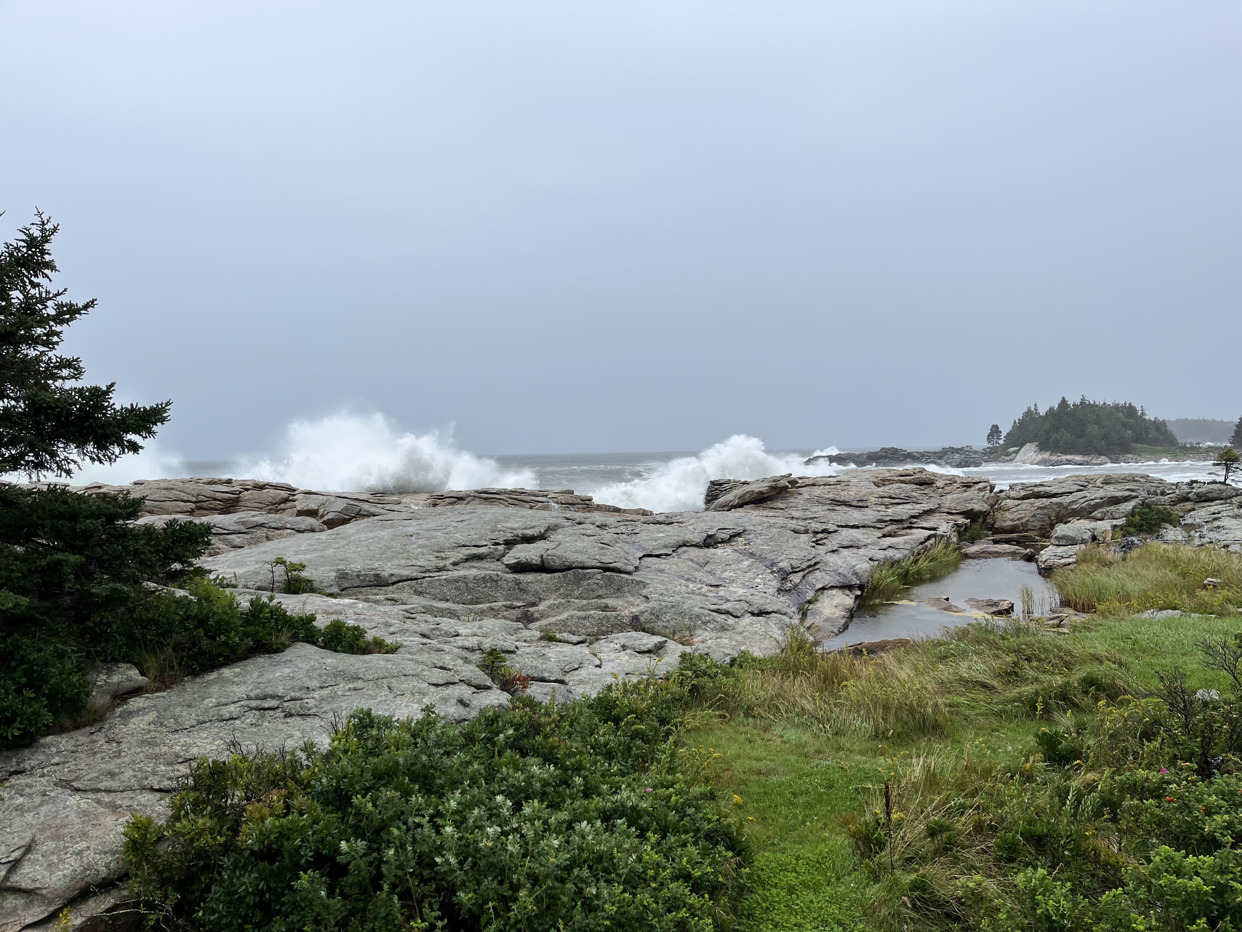
Lee arrived with 10-15 foot surf from the southeast, but the northwest winds kept the waves from washing over all the rocks into our yard.


The surf pounded the other side of our cove, but we were spared most of the force.


Sunday, September 10, 2023

The Great Halifax Explosion, the Bluenose, Fog and other Nova Scotia Highlights

Halifax

Panorama view of one of the cruise ships in Halifax Harbor.

Salty Paws in busy Halifax Harbor.

The Halifax waterfront has a mile boardwalk along the docks and is lined with restaurants and shops.

We steered Salty Paws out of main channel to let the car carrier Sunshine Ace exit Halifax Harbor.  The yellow boat will pick up the harbor pilot from the ship once it is outside the harbor.  The transfer is done while both boats are moving.

The year was 1917.  The day was December 6th.  World War I was raging, and the city of Halifax was a very active seaport being the closest major port to Europe.  Among the ships in harbor were the Imo, a Belgian relief supply ship, and the Mont-Blanc, a French munitions ship carrying almost 3,000 tons of explosive material.  Due to a series of ill-advised maneuvers, the Imo rammed the bow of the Mont-Blanc.  The collision itself was minor except that the impact started a fire on the French vessel.  As the fire intensified, many city residents hurried down to the docks to see what was happening.  
Picture taken at the Maritime Museum

 Twenty minutes after the initial collision the Mont-Blanc exploded with a violent chemical reaction, releasing energy at 5,000 feet per second.  Almost 2,000 people died immediately and another 9,000 were injured.  1,630 homes were completely destroyed, 12,000 houses were damaged and over 6,000 survivors were homeless.  Many of the windows throughout the city were shattered leaving many blinded and many in need of surgery to remove glass embedded  in their eyes.  The blast also created a local tsunami that wiped out a nearby community of the Mi’kmaq First Nation, that had existed for generations.

 The explosion was the largest man-made blast prior to the atomic bomb, and the recovery effort was made even more difficult when a snowstorm the next day dropped 16 inches of snow on Halifax.  If there was any good news about the explosion, it was the world-wide response to assist Halifax in its recovery.  Boston and Massachusetts were particularly helpful, and among their most prized contributions were window glass and 24 window glazers.  Every year Halifax and Nova Scotia cut and ship to Boston a magnificent, large Christmas tree in gratitude.

Halifax today is one of the fastest growing cities in  North America and has a population approaching 400,000.  The British founded Halifax in 1749 and made the city its base for naval operations in North America.  There were at least three reasons for this decision - the port is large, ice-free year round and close enough to counter the French fleet in Louisburg, located roughly 200 miles to the east.

We walked to the Citadel, a fort that has
  been rebuilt 4 times and protected the
city for 200+ years.

At the Maritime Museum we learned that in 1758 the British surprised the French in Louisburg leading in short order to the French surrender there.  By 1763 the French had acceded all of Canada to the British.  Even after that, however, the British continued to have a large garrison in Halifax to guard against the upstart colonists and then the new United States.  In fact, for well over 100 years the Americans and the British viewed the other as the enemy.

The city continues to be a large shipping port, and the harbor is lined with a cruise ship berth, a large container facility and more.  The old wharves have been fully rehabbed and floating docks added for recreational boats.  Every 30 feet of dock has a reservation sign showing the boat’s name, length and dates reserved.  Unfortunately, the wharf reservation system is questionable as they do not take same day registrations, payment is only upon departure, and the majority of the reserved slips were empty.  

We were able to find one slip with an expired reservation date.  I tried to pay the dock fee over the telephone, but was told that they couldn’t take payment but would call back later.  (They never did.). Soon, we experienced the downside to this perfect location - boat wakes in the harbor.  Between the wakes and the partying (it was their Labor Day weekend), we didn’t get much sleep that night.

LaHave and Lunenburg

Salty Paws at Anne Huntington’s Bell Island dock.

The LaHave Bakery and dock.
Anne Huntington and Dick.

The LaHave Islands are beautiful, and we were blessed to be able to dock for the night and have a home-made dinner with Dick’s friend Anne Huntington at her house on Bell Island.  This was followed by two nights at LaHave Bakery, only a 5 minute walk from Molly and my friends, Merydie and Ken Houldsworth.  We first met them in the Bahamas in 2016.  

The LaHave Bakery along with a bookstore, consignment store and restaurant are all located in the restored LaHave Outfitters building that once served the now almost gone local fishing industry.  They have a dock where cruisers can dock free during the day or spend the night for $1 per foot.


Merydie and Ken.
The Bluenose II

 Merydie and Ken hosted us for cocktails and dinner, and Ken drove us to Lunenburg with its UNESCO designated world heritage site on its waterfront.  We toured the Fisheries Museum and walked aboard the famous Bluenose II.

The story of the boat is quite a tale, and started in 1920 when the Halifax Express newspaper offered a $4,000 prize for the fastest fishing vessel in a best two out of three races called the International Fisherman’s Cup Race.  To be eligible a vessel had to have fished in the Grand Banks for at least one season.

This topographical map in the Fisheries Museum shows the various fishing banks off the New England and Atlantic Canada.  The Grand Banks is off Newfoundland on the far right.

Elimination races were used off Halifax to determine the Canadian vessel and off New Gloucester, MA to pick the American representative.  To the surprise and consternation of the Canadians, the New Gloucester boat won the inaugural cup.  The Canadians then engaged in a crash course to design, build and fish in a new boat o qualify for the 1921 race.  The boat was constructed in Lunenburg and finished in less than 6 months.  It was named the Bluenose, the nickname for people from Nova Scotia.  After easily winning the elimination races to represent Canada, Bluenose won both races against the US representative and returned the Fisherman’s Cup trophy to Canada.  The boat also won the subsequent Fisherman’s Cup races in 1922, 1923, 1931 and the last one in 1938.  The age of sail was now completely over for commercial vessels as sails were replaced by steam engines.

Dick aboard the Bluenose II.


The Bluenose was a tremendous source of pride for Canadians and appeared in postage stamps and on the back of their dime.  It was sold in 1942, however, and met its demise in 1946 after hitting a reef off Haiti.   In 1963 the Orlando Brewery financed the construction of the Bluenose II to be used as a promotional yacht.  It was given to the provincial government in 1971 and continues to sail out of Lunenburg as an Canadian ambassador.


Nova Scotia Fog

Cape Sable Light.  The fog lifted temporarily to give us a great view. 

Our view from the boat while cruising from the Nova Scotia southwestern coast to the Bay of Fundy.

You can not read the ship
names, but each line is a wreck.


Almost 40 years ago my father, a friend and I sailed from Portland to Nova Scotia.  We arrived in fog, the Province’s 48th straight day of fog.  The cold waters of the Atlantic and moist southerly are a perfect recipe for fog.  Until this week we have had very little fog on this trip, but it arrived in earnest on our day to round Cape Sable, sometimes referred to as “the Graveyard of the Atlantic.”  Hundreds of vessels have run aground on its shoals, so a clear view is most desirable.  

We went by the Cat in Yarmouth before
it left on its daily run to Bar Harbor, ME.

Unlike the ships of the past, however, we have modern technology on Salt Paws including two depth sounders and two independent chartplotters using Global Positioning System (GPS) that show our speed, direction and exact location on the water.  Another great advancement is our Automated Identification System (AIS) that displays the position of nearby boats right on our chartplotter, and other boats can see us.  AIS is generally required on commercial vessels, and most cruisers also have the system.  We also blow our fog horn frequently.

We left our anchorage at Cape Negro Island across from Squaw Island (they still have these names?), and Dick and I swapped 1 1/2 hour shifts at the helm.  We would go crazy if we had to pilot boats in these conditions every day.  As Salty Paws approached Cape Sable, the fog lifted temporarily and sunlight radiated off the beautiful lighthouse.  After rounding the dangerous shoal, we soon found ourselves in fog again.  Twice we passed other boats only 0.2 miles away, but we never saw either of them.

Annapolis Royal

Salty Paws on one of fishing boat mooring at Annapolis Royal,

When we walked into the town on Sunday
morning, there was no one around. We
felt like we were on a movie set.
More than one Canadian told us that you have to go to Annapolis Royal, located 10 miles up the Annapolis River from Digby on the Bay of Fundy.  We took the bait and cruised up the Bay of Fundy to the quaint little town with quite a history including being the first permanent European settlement north of St. Augustine, FL.  The French established a presence here in 1605, although they would not have survived without the assistance of the local Mi’kmaq inhabitants.  Over the next 100 years the settlement and the fort here would change hands 6 times in battles between the France and Britain before the British prevailed in 1710. 


Dick and I toured Fort Anne here which was Canada’s first national historical site.   As in other historical sites we visited, we learned more about the expulsion of the Acadians and also the treaties made with the Mi’kmaq that were not honored by the British.

We were pleasantly surprised to find a bar that would let us watch the New England Patriots season opener, and below the TV was a Patriots helmet signed by Tom Brady!


Peggy’s Cove
Salty Paws is that little boat out there.

This is one of the top tourist attractions in Nova Scotia because of its picturesque lighthouse and quaint small harbor.  There are two live webcams there, and a Salty Paws was captured by both.  I observed 5 large busses in the parking lot.

Salty paws is in the center of the picture.


Friday, September 1, 2023

A Spy, Nova Scotia's Eastern Shore and Brown Water

A sailboat shared our first anchorage on the Eastern Shore of Nova Scotia.  (Louise Harbor, Seal Cove)

Comments by other boats mentioned the lack of cell service in Seal Cove because of the high cliffs.  After experiencing
Newfoundland, we just didn't see any!

We cruised by Canso, a major fishing port on the tip of the eastern Nova Scotia mainland.


Dick and I on Salty Paws spent four nights at Liscombe Lodge while waiting for sea conditions to improve.

Heavy rains the day before made the trails impassable, but were able to ride mountain bikes
to Liscomb Falls.

Molly at the wheel in seas that she likes!
Molly, my spouse, is a saint.  In our numerous travels on Salty Paws she has broken a toe in rough conditions, experienced the boat broaching, and stressed through too many times when seas and winds greatly exceeded what was forecasted.  She has reached her limit on open-water passages, and, as many of you know, Molly opted out of this adventure after Quebec City and was replaced by our friend, Dick Klain.

What I did not realize, is that her level of discomfort does not diminish when she is ashore and I am out in open water.  She can monitor Salty Paw’s progress in real time using the Garmin weblink http://share.garmin.com/CruisingonSaltyPaws that picks up our location, speed, and direction via satellite.  Perhaps, this is a mistake to have such technology!  During last week’s 200-mile crossing from Newfoundland to Cape Breton our buddy boat Vega and Salty Paws stopped half way across.  We quickly received a satellite text from Molly:

Molly: “What is going on??? Why the slow speed and change of direction??? Is it too rough? Are you turning around?

Me: “You are a spy!  I was legally emptying the contents of the composting toilet into the ocean!”

Molly: “Yes, I am a spy!”

The Garmin weblink shows our route to-date and the present location of Salty Paws along with boat speed and direction.

80 miles from any shore Otto adjusted a line on his bow while
I dumped out the contents in our composting toilet.

That passage across Cabot Strait was relatively smooth, and we were able to average around 14 mph.  We approached the Cape Breton coast as the sun set with still 30 miles to go.  Soon, the half moon was behind a cloud, and we were in complete darkness except for the lights from the still distant shore and the navigational lights on our two boats.  If you have not navigated at night, or even if you have, the lights and distances can be very deceiving.  A light that appears close, can be far away, and a light that appears far away can be close.

This is like what we saw in
the sky.  Downloaded from
Yahoo images.
From this distance we saw white, red, and green lights providing passage to three different harbor entrances.   Using the chart, I was able to discern the correct one although what seems just a couple of miles away was 10.  Then, we saw a large red circle in the sky in front of us.  At first, I was thinking that Canada has developed some new high tech navigation aid.  Then we realized that it was from fireworks on the shore.

Vega and Salty Paws tied up to a fishing boat off Little Bras d'Or.

Finally, we reached calm waters just inside Little Bras d’Or and pulled into the nearby fishing port around 10:30 pm.  There was no room to anchor, but I was able to call out to someone on shore who immediately gave us permission to tie up to a fishing boat.;  Once Salty Paws was secure, Vega tucked in next to us.  Otto, Dick and I then unwound with Bourbon or Scotch along with a nut mix and peanut butter and saltines.  We finally took for our berths at 11:30 pm or so.

Our next day’s 70-mile passage through the Bras d’Dor Lake was a little rough but manageable until we got to the main part of the Lake.   While the forecast was windy but calm seas in the Lake, we got the wind and 4-5 foot seas on top of each other.  The text comes in almost immediately:

Molly: “You have slowed down.  Are you in rough seas?  Should you be out there?”

Well, here she had me, but I had altered course to get to the lee shore as quickly as possible.  I soon was able to text “We are fine, but the conditions in the middle of the Lake were worse than forecasted.”  We later learned that the forecast for Bras d’Or Lake always understates the impact of winds for the center of the Lake!  Shortly thereafter the call came in:

Molly: “Dick in his emails tells it like it is with the weather, but you don’t share with me how bad it is.  I want to know all the details!” 

Me: “But I haven’t even done my blog yet for this section.”

What am I to do?  At least when Molly was with me, she never accused me of sheltering her from the facts because she was experiencing them directly!   Of course, if the weather cooperated and was always calm, that would be no issue. 

We ended our boating day at St. Peter’s Marina, near the canal used to exit the western end of Bras d’Or Lake.  Shortly after arrival, Vega was pulled out of the water.  Otto then gave us a quick tour of the town in his truck before he departed to drive to North Sydney to pick up Rob, who left his boat, Sea Hag, in Newfoundland, and took the ferry back to Cape Breton.  Rob had earlier decided not to chance the crossing with us, and would get his truck and trailer in St. Peter’s and go back on the ferry to pick up his boat.  Rob texted us a goodbye message the next morning, and Otto came by so we could give each other big hugs on our successful adventure.  He then drove the 1,500 miles home to Webster, New York, in two days!

Our route through the islands.  Blue is for 
August 28th.  Red is for August 29th.

I felt like I was in Maine while cruising
through the Eastern Nova Scotia Islands.
Salty Paws with Dick and me is now cruising down the eastern Nova Scotia coast, which could easily be mistaken for Maine.  The coast is dotted with islands, mostly covered with spruce and fir, and lined with solid granite shores and rocky beaches.  For the next three days we docked at Liscombe Lodge Resort as while waiting for seas to calm down from numerous thunder storms and Franklin, the hurricane that is far offshore.  Seas along the coast have had up to 10-feet swells with an 8 second period.  Our threshold is no more than 3-foot swells with at least a 6-second period.  We will soon learn if seas have quieted down enough as we will leave the Liscombe Lodge.  At the recommendation of the tour boat operator here, we are leaving Friday afternoon, September 1st, rather than early Saturday, September 2th, because the wind today is off the land. Our next major destination is Halifax.

The water color as we enter the
 mouth of the Liscomb River.


I should mention that the fresh water flowing in the ocean throughout Atlantic Canada is brown in color.  This is not due to pollution, but rather the tannin from decaying vegetation.  It also occurs in Maine and other states that are heavy with vegetation, but it is much darker here.   In the Newfoundland outports, this is also the color of the drinking water as it comes directly from streams and lakes without filtration.  Interestingly, the color disappears in the winter due to freezing and/or less plant decay.

Below are pictures that highlight our 3-day stay at the Liscombe Lodge dock.

Liscombe Lodge is a somewhat tired, but welcomed resort on the Eastern coast in rural Nova Scotia.
It started as fishing camp in 1960, was purchased by the province in 1976 in their effort to promote tourism and returned to private hands in 2020.

Dick and I used the Lodge's bicycles to bike to Liscomb Falls and the Liscomb Fish Ladder on a rough dirt road, often covered with water from all the rain.

Panaroma showing Liscomb Falls to the left and the swinging bridge.

Adjacent to the swinging bridge is the part of the large pipe for the hydroelectic plant built in 1903.
It funneled water from the falls through a turbine.  The plant operated for a few decades and gave rise
to the need for a fish ladder to help spawning Atlantic Salmon.

Here we are standing at the top of the fish ladder. The high water level obscures the fish ladders below,
but one can make out some of the ladder sections.

The hot tub and pool were a nice distraction, and I learned that Dick used to be a competitive swimmer at the University of Connecticut.

Any chess players out there? The queen pawn opening is one of my favorites!