 |
| The Acadian flag. |

 |
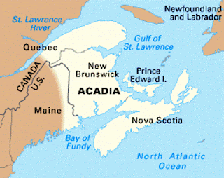
| Acadia (copied from inalldirections.blog) |
 |
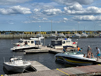
| Acadian flags in front of the marina in Caraquet. |
 |
| Mimi, Jacques, Michel and me in front of our two Rosboroughs, Salty Paws and their boat, Tomorrow. |
Concurrent with our immersion into Acadian history was our connecting with some native Quebecers, who speak very little English. Earlier, I had received a Facebook message in French from Jacques Thibault, who also owns a Rosborough and is a member of the same Rosborough Facebook group as I am. He invited us for a visit and hoped that we might be able to cruise together with his wife, Mimi, and good friend Michel Manningham. After many emails and text messages in French, we did just that. I actual became quite proficient, not in French, but in the use of Google Translate!
 |
| Dick led the shucking effort, and we all had an allocation of four ears each. |
They treated us to dinner at their home in Carlton sur Mer attended by 15 or so of their friends and neighbors. The menu was fresh corn and hotdogs. We all shared in the shucking, and everyone had a great time. I was even able to have multiple conversations using a Google Translate although some of the translations had everyone laughing. I am sure that there are some major differences between Parisian French and Quebec French!
 |
| Conversation stoped once the corn was served. |
 |
| The dinner guests except for two who didn’t want their picture taken. |
 |
| Cocktail hour on Salty Paws. |
We cruised together for three days and nights, visiting unique places that were not on our original itinerary. After crossing the 30-mile wide Bay of Chalour, we went into the Caraquet, the informal capital of Acadia. The marina was first class with free laundry, which is unheard of. Everything was in French, but now I can at least order my own ice cream cone!
Our next night I thought we had agreement to go to Val Comeau, 60 miles south. Salty Paws led the way there, going through the breakwater inlet and bearing left for a mile up the narrow channel to this small fishing village. As it turns out our cruising partners wanted to go to Tracadie, which was 6 miles up a creek bearing right after the breakwater. This route hasn’t even made the nautical charts!
 |
| Usually blue water on a nautical chart indicates Shallow water that one should not enter! The green checkered line were the “breadcrumbs” made by my chartplotters to help with the return trip. |
Our last day together was calm and beautiful. We cruised over 60 miles and ended up at a small marina in Richibucto. This former industrial center has many visual remembrances of its heritage including the dilapidated pier at the River mouth that used to be a fish rendering plant. The River itself has numerous rock piles left by 19th century ships from Europe that crossed the ocean and dropped their ballast before picking up loads of pulp wood.
 |
| Tomorrow and Salty Paws at the Richibuto Marina. |
There is also a waterfront park that pays homage to the town being a refuge to Acadians seeking to avoid The Great Expulsion. And, then there are the ghosts, or were the ghosts. As we learned, bootlegging alcohol was a big source of income during prohibition. The bootleggers promoted stories about haunted "spirits" in their midst. Newspaper accounts, frightened locals and an understaffed law enforcement allowed the bootleggers more opportunity to continue their trade without interruption.
 |
| We buried our bow more than once but boat and crew were fine. |
 |
| Parlee Beach was empty. |
After a nice breakfast we departed and continued to hug the shallow coast. We made a short side trip to Parlee Beach, famous for having the warmest water north of the Carolinas because of the Gulf Stream. Dick and I planned to anchor for a quick swim off the boat, but light rain and 61 degree water had us easily decide otherwise.
At the day’s 45-mile mark sea conditions worsened as we approached the 9-mile long Confederation Bridge that connects New Brunswick and Prince Edward Island.
I took the helm from Dick, and turned off the autopilot to hand steer. We latched all the doors and put on life jackets for what proved to be the longest, roughest hour of the whole cruise to-date (and we hope never to repeat it!). We were 6 or so miles from a small, protected fishing port located south of the bridge. Swells were coming at us as high as 7 feet, and to enter the port we would have to be broadside to the swells for up to a mile. Using constant hand steering and throttle speed adjustments, I was partially successful in reducing the pitching of the boat. We slowly made our way while Salty Paws bounced up and down and side to side. Finally, we were inside the outer breakwater and then the inner breakwater.
 |
| Fishing pier at Cap Tormintine. That name makes sense! |
We tied up to the pier, and enjoyed the calm with a cocktail, our last crackers and a card game. Then the weather update came in offering greatly improved conditions beginning early evening. A walk to the end of the pier and primary seawall confirmed that seas had greatly lessened.
We decided that we would have supper and then depart for Charlottetown, 42 miles way. We left at 6:20 pm, and were anchored in Charlottetown by 9 pm and just before the light faded from the sky. All is well.
The next morning was very relaxing and featured great blueberry pancakes. Just beofre noon we raised the anchor and motored the 1/2 mile to the Charlottetown Yacht Club where Salty Paws will remain for the next three days. Molly and Dick's wife, Ellen, are due to arrive by car late afternoon. |
| Everything tastes great on a boat! |
 |
| Beaches make up most of the eastern shore of New Brunswick. |
 |
| Lobster boats are primarily idle in the off-Season, which is most of the year! The season is only 68 days long but is lucrative enough to support the industry. This is in Richibucto. |


No comments:
Post a Comment